
Rigorous attempts to warn of tornadoes began in the United States in the mid-20th century. Before the 1950s, the only method of detecting a tornado was by someone seeing it on the ground. Often, news of a tornado would reach a local weather office after the storm. However, with the advent of weather radar, areas near a local office could get advance warning of severe weather. The first public tornado warnings were issued in 1950 and the first tornado watches and convective outlooks in 1952. In 1953 it was confirmed that hook echoes are associated with tornadoes. By recognizing these radar signatures, meteorologists could detect thunderstorms probably producing tornadoes from dozens of miles away.
Radar
Today, most developed countries have a network of weather radars, which remains the main method of detecting signatures probably associated with tornadoes. In the United States and a few other countries, Doppler weather radar stations are used. These devices measure the velocity and radial direction (towards or away from the radar) of the winds in a storm, and so can spot evidence of rotation in storms from more than a hundred miles (160 km) away. When storms are distant from a radar, only areas high within the storm are observed and the important areas below are not sampled. Data resolution also decreases with distance from the radar. Some meteorological situations leading to tornadogenesis are not readily detectable by radar and on occasion tornado development may occur more quickly than radar can complete a scan and send the batch of data. Also, most populated areas on Earth are now visible from the Geostationary Operational Environmental Satellites (GOES), which aid in the nowcasting of tornadic storms.

Storm spotting
In the mid-1970s, the U.S. National Weather Service (NWS) increased its efforts to train storm spotters to spot key features of storms which indicate severe hail, damaging winds, and tornadoes, as well as damage itself and flash flooding. The program was called Skywarn, and the spotters were local sheriff's deputies, state troopers, firefighters, ambulance drivers, amateur radio operators, civil defense (now emergency management) spotters, storm chasers, and ordinary citizens. When severe weather is anticipated, local weather service offices request that these spotters look out for severe weather, and report any tornadoes immediately, so that the office can warn of the hazard.
Usually spotters are trained by the NWS on behalf of their respective organizations, and report to them. The organizations activate public warning systems such as sirens and the Emergency Alert System, and forward the report to the NWS. There are more than 230,000 trained Skywarn weather spotters across the United States.
In Canada, a similar network of volunteer weather watchers, called Canwarn, helps spot severe weather, with more than 1,000 volunteers. In Europe, several nations are organizing spotter networks under the auspices of Skywarn Europe and the Tornado and Storm Research Organisation (TORRO) has maintained a network of spotters in the United Kingdom since 1974.
Storm spotters are needed because radar systems such as NEXRAD do not detect a tornado; merely signatures which hint at the presence of tornadoes. Radar may give a warning before there is any visual evidence of a tornado or imminent tornado, but ground truth from an observer can either verify the threat or determine that a tornado is not imminent. The spotter's ability to see what radar cannot is especially important as distance from the radar site increases, because the radar beam becomes progressively higher in altitude further away from the radar, chiefly due to curvature of Earth, and the beam also spreads out.
Visual evidence
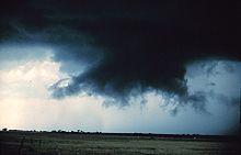
Storm spotters are trained to discern whether a storm seen from a distance is a supercell. They typically look to its rear, the main region of updraft and inflow. Under the updraft is a rain-free base, and the next step of tornadogenesis is the formation of a rotating wall cloud. The vast majority of intense tornadoes occur with a wall cloud on the backside of a supercell.
Evidence of a supercell comes from the storm's shape and structure, and cloud tower features such as a hard and vigorous updraft tower, a persistent, large overshooting top, a hard anvil (especially when backsheared against strong upper level winds), and a corkscrew look or striations. Under the storm and closer to where most tornadoes are found, evidence of a supercell and likelihood of a tornado includes inflow bands (particularly when curved) such as a "beaver tail", and other clues such as strength of inflow, warmth and moistness of inflow air, how outflow- or inflow-dominant a storm appears, and how far is the front flank precipitation core from the wall cloud. Tornadogenesis is most likely at the interface of the updraft and rear flank downdraft, and requires a balance between the outflow and inflow.
Only wall clouds that rotate spawn tornadoes, and usually precede the tornado by five to thirty minutes. Rotating wall clouds are the visual manifestation of a mesocyclone. Barring a low-level boundary, tornadogenesis is highly unlikely unless a rear flank downdraft occurs, which is usually visibly evidenced by evaporation of cloud adjacent to a corner of a wall cloud. A tornado often occurs as this happens or shortly after; first, a funnel cloud dips and in nearly all cases by the time it reaches halfway down, a surface swirl has already developed, signifying a tornado is on the ground before condensation connects the surface circulation to the storm. Tornadoes may also occur without wall clouds, under flanking lines, and on the leading edge. Spotters watch all areas of a storm, and the cloud base and surface.
No comments:
Post a Comment