

The earthquake which was caused by 5 to 8 meters upthrust on a 180-km wide seabed at 60 km offshore from the east coast of Tōhoku resulted in a major tsunami which brought destruction along the Pacific coastline of Japan's northern islands and resulted in the loss of thousands of lives and devastated entire towns. The tsunami propagated across the Pacific, and warnings were issued and evacuations carried out. In many countries bordering the Pacific, including the entire Pacific coast of North and South America from Alaska to Chile; however, while the tsunami was felt in many of these places, it caused only relatively minor effects. Chile's section of Pacific coast is one of the furthest from Japan, at about 17,000 km (11,000 mi) away, but still was struck by tsunami waves 2 m (6.6 ft) high. A wave height of 38.9 meters (128 ft) was estimated at Omoe peninsula, Miyako city, Iwate prefecture.
Japan
The tsunami warning issued by the Japan Meteorological Agency was the most serious on its warning scale; it rated as a "major tsunami", being at least 3 m (9.8 ft) high. The actual height predicted varied, the greatest being for Miyagi at 6 m (20 ft) high. The tsunami inundated a total area of approximately 561 km2 (217 sq mi) in Japan.
The earthquake took place at 14:46 JST around 67 km (42 mi) from the nearest point on Japan's coastline, and initial estimates indicated the tsunami would have taken 10 to 30 minutes to reach the areas first affected, and then areas farther north and south based on the geography of the coastline. Just over an hour after the earthquake at 15:55 JST, a tsunami was observed flooding Sendai Airport, which is located near the coast of Miyagi Prefecture, with waves sweeping away cars and planes and flooding various buildings as they traveled inland. The impact of the tsunami in and around Sendai Airport was filmed by an NHK News helicopter, showing a number of vehicles on local roads trying to escape the approaching wave and being engulfed by it. A 4 m high tsunami hit Iwate Prefecture. Wakabayashi Ward in Sendai was also particularly hard hit. At least 101 designated tsunami evacuation sites were hit by the wave.
Like the 2004 Indian Ocean earthquake and tsunami, the damage by surging water, though much more localized, was far more deadly and destructive than the actual quake. There were reports of entire towns destroyed from tsunami-hit areas in Japan, including 9,500 missing in Minamisanriku; one thousand bodies had been recovered in the town by 14 March 2011.
Among several factors causing the high death toll from the tsunami, one was the unexpectedly large size of the water surge. The tsunami walls at several of the affected cities were based on much smaller tsunami heights. Also, many people caught in the tsunami thought that they were located on high enough ground to be safe.

Kuji and Ōfunato were almost entirely destroyed Also destroyed was Rikuzentakata, where the tsunami was reportedly three stories high. Other cities reportedly destroyed or heavily damaged by the tsunami include Kamaishi, Miyako, Ōtsuchi, and Yamada (in Iwate Prefecture), Namie, Sōma and Minamisōma (in Fukushima Prefecture) and Shichigahama, Higashimatsushima, Onagawa, Natori, Ishinomaki, and Kesennuma (in Miyagi Prefecture). The most severe effects of the tsunami were felt along a 670-km (420 mi)-long stretch of coastline from Erimo in the north to Ōarai in the south, with most of the destruction in that area occurring in the hour following the earthquake. Near Ōarai, people captured images of a huge whirlpool that had been generated by the tsunami. The tsunami washed away the sole bridge to Miyatojima, Miyagi, isolating the island's 900 residents. A two meter high tsunami hit Chiba Prefecture about 2 1/2 hours after the quake, causing heavy damage to cities such as Asahi.
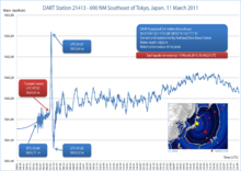
On 13 March 2011, the Japan Meteorological Agency (JMA) published details of tsunami observations recorded around the coastline of Japan following the earthquake. These observations included tsunami maximum readings of over 3 m (9.8 ft) at the following locations and times on 11 March 2011, following the earthquake at 14:46 JST:
- 15:12 JST – off Kamaishi – 6.8 m (22 ft)
- 15:15 JST – Ōfunato – 3.2 m (10 ft) or higher
- 15:20 JST – Ishinomaki-shi Ayukawa – 3.3 m (11 ft) or higher
- 15:21 JST – Miyako – 4.0 m (13.1 ft) or higher
- 15:21 JST – Kamaishi – 4.1 m (13 ft) or higher
- 15:44 JST – Erimo-cho Shoya – 3.5 m (11 ft)
- 15:50 JST – Sōma – 7.3 m (24 ft) or higher
- 16:52 JST – Ōarai – 4.2 m (14 ft)
These readings were obtained from recording stations maintained by the JMA around the coastline of Japan. Many areas were also affected by waves of 1 to 3 meters (3.3 to 9.8 ft) in height, and the JMA bulletin also included the caveat that "At some parts of the coasts, tsunamis may be higher than those observed at the observation sites." The timing of the earliest recorded tsunami maximum readings ranged from 15:12 to 15:21, between 26 and 35 minutes after the earthquake had struck. The bulletin also included initial tsunami observation details, as well as more detailed maps for the coastlines affected by the tsunami waves.
On 23 March 2011, Port and Airport Research Institute reported tsunami height by visiting the port sites or by telemetry from offshore as follows:

- Port of Hachinohe – 5–6 m (16–19 ft)
- Port of Hachinohe area – 8–9 m (26–29 ft)
- Port of Kuji – 8–9 m (26–29 ft)
- Mooring GPS wave height meter at offshore of central Iwate (Miyako) – 6 m (20 ft)
- Port of Kamaishi – 7–9 m (23–30 ft)
- Mooring GPS wave height meter at offshore of southern Iwate (Kamaishi) – 6.5 m (22 ft)
- Port of Ōfunato – 9.5 m (31 ft)
- Run up height, port of Ōfunato area – 24 m (79 ft)
- Mooring GPS wave height meter at offshore of northern Miyagi – 5.6 m (18 ft)
- Fishery port of Onagawa – 15 m (50 ft)
- Port of Ishinomaki – 5 m (16 ft)
- Mooring GPS wave height meter at offshore of central Miyagi – could not measure
- Shiogama section of Shiogama-Sendai port – 4 m (13 ft)
- Sendai section of Shiogama-Sendai port – 8 m (26 ft)
- Sendai Airport area – 12 m (39 ft)
A joint research team from Yokohama National University and the University of Tokyo also reported that the tsunami at Ryōri Bay (綾里白浜), Ōfunato was about 30 m high. They found fishing equipment scattered on the high cliff above the bay. At Tarō, Iwate, a University of Tokyo researcher reported an estimated tsunami height of 37.9 m (124 ft) reached the slope of a mountain some 200 m (656 ft) away from the coastline. Also, at slope of nearby mountain from 400 m (1,312 ft) Aneyoshi fishery port (姉吉漁港) of Omoe peninsula (重茂半島) in Miyako, Iwate, Tokyo University of Marine Science and Technology found estimated tsunami run up height of 38.9 m (127 ft). This height is deemed the record in Japan historically, as of reporting date, that exceeds 38.2 m (125 ft) from the 1896 Meiji-Sanriku earthquake.
Elsewhere across the Pacific

Shortly after the earthquake, the Pacific Tsunami Warning Center (PTWC) in Hawaii issued tsunami watches and announcements for locations in the Pacific. At 07:30 UTC, PTWC issued a widespread tsunami warning covering the entire Pacific Ocean.[118][119] Russia evacuated 11,000 residents from coastal areas of the Kuril Islands.[120] The United States West Coast and Alaska Tsunami Warning Center issued a tsunami warning for the coastal areas of most of California, all of Oregon, and the western part of Alaska, and a tsunami advisory covering the Pacific coastlines of most of Alaska, and all of Washington and British Columbia, Canada. In California and Oregon, up to 2.4 m (8 ft) high tsunami surges hit some areas, damaging docks and harbors and causing over US$10 million in damage. Surges of up to 1 m (3.3 ft) hit Vancouver Island in Canada prompting some evacuations, and causing boats to be banned from the waters surrounding the island for 12 hours following the wave strike, leaving many island residents in the area without means of getting to work.

In the Philippines, waves up to 0.5 m (1.6 ft) high hit the eastern seaboard of the country. Some houses along the coast in Jayapura, Indonesia were destroyed. Authorities in Wewak, East Sepik, Papua New Guinea evacuated 100 patients from the city's Boram Hospital before it was hit by the waves, causing an estimated US$4 million in damages. Hawaii estimated damage to public infrastructure alone at US$3 million, with damage to private properties, including resort hotels such as Four Seasons Resort Hualalai, estimated at tens of millions of dollars. It was reported that a 1.5 m (5 ft) high wave completely submerged Midway Atoll's reef inlets and Spit Island, killing more than 110,000 nesting seabirds at the Midway Atoll National Wildlife Refuge. Some other South Pacific countries, including Tonga and New Zealand, and U.S. territories American Samoa and Guam, experienced larger-than-normal waves, but did not report any major damage. However in Guam some roads were closed off and people were evacuated from low-lying areas. In Curry County, Oregon $7 million in damages occurred including the destruction of 3,600 feet of dockspace at the Brookings harbor; the county has received over $1 million in FEMA emergency grants.
Along the Pacific Coast of Mexico and South America, tsunami surges were reported, but in most places caused little or no damage. Peru reported a wave of 1.5 m (5 ft) and more than 300 homes damaged. The surge in Chile was large enough to damage more than 200 houses, with waves of up to 3 m (9.8 ft). In the Galapagos Islands, 260 families received assistance following a 3 m (9.8 ft) surge which arrived 20 hours after the earthquake, after the tsunami warning had been lifted. There was a great deal of damage to buildings on the islands and one man was injured but there were no reported fatalities.